![]() DE
DE ![]() FR
FR
Bättlerloch
Karstlehrpfad Kaltbrunnental-Brislachallmet
![]() DE
DE ![]() FR
FR
Bättlerloch
Karstlehrpfad Kaltbrunnental-Brislachallmet
![]()
![]()
![]()
![]()
![]()
![]()
![]()
![]()
An interpretation of the cave name Bättlerloch assumes that beggars, vagabonds or gypsies have chosen the cave as a sheltered resting place.
The Bättlerloch is also known as the bath of the underground little people, who took a bath here after work is done. Sagas are widespread in north-western Switzerland, so every second community in the Upper Basel area and in the Frick Valley has a cave associated with a mythological character such as a gnome or his wife. These caves were home to the dwarf figures who secretly completed the work of mankind. Unfortunately, the nosiness of the peasant women led them to scatter ashes so they might follow the tracks of the mysterious helpers. But the only thing they found were impressions of goosefeet - the friendly earth people disappeared from then on.
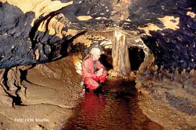
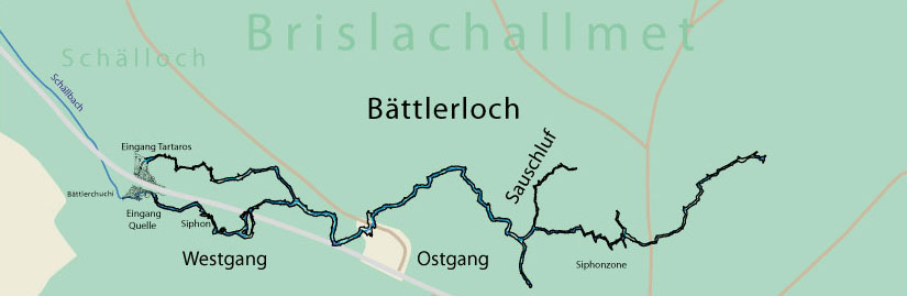
Bättlerloch holds the record as the longest explored cave in Basel-land. Despite its impressive length, the difference
in altitude within it is only 8m at its maximum.
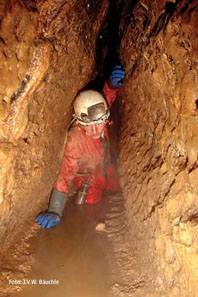
There are two narrow entrances, one of which is the source from which the cave stream flows and the other is the Tartaros passage. Only the Tartaros leads to the back of the cave without diving. The main corridor (east corridor) is more spacious; the last 180m of the corridor are blocked by a siphon and the possible continuation is blocked by sinter deposits. The Sauschluf and the Südgang are the only two branches of the main corridor, both are very narrow and especially unpleasant due to their muddy water basins.
The origin of the water is unknown, but it reacts very quickly to thunderstorms. A rise of the water level above 20cm is very rare.
Avoid visits between December and March to prevent water turbidity from affecting fish farming below the source.
Geologie
The sedimentary rocks in the Basel region and Schwarzbubenland originate from three periods of marine cover: 240 million years ago during the Middle Triassic, 200-145 million years ago during the Jura and 32 million years ago in the Middle Tertiary. At these times, gypsum/anhydrite and rock salt, and particularly lime and clay stones, were deposited. In addition to biogenic limestone, which consists mainly of shells, skeletons of the smallest sea creatures and corals, lime was precipitated chemically, often in the form of small beads around condensation cores, as very fine-grained lime mud. Particularly striking is the reservoir rock from the Middle Jurassic, which consists mainly of these globules, which look like fish roe (caviar!). Hence the name in german, Fischrogen. When the Alps were folded, the originally horizontal layers in the south of northwestern Switzerland were raised to the Jura Mountains, also known as the Folded Jura Mountains or the Jura Mountain Chain. By contrast, the north of northwestern Switzerland was not included in the fold. Instead, the layers here were only slightly tilted to the south. This area is called Jura Plateau. Both areas are karst areas and therefore typical cave areas. Usually the mountains here are very rugged and the original sediment layers are composed of many small broken rocks and cracks. This is one reason why only relatively short cave systems are known here compared to the huge systems in the foothills of the Alps. A small exception is here in the Laufen Basin which contains the 1 km long Bättlerloch cave.